Neighborhood guide

South Boston

Triple-deckers, corner bars and Broadway up top; beaches, a harbor-front loop and a granite fort on Castle Island down below.

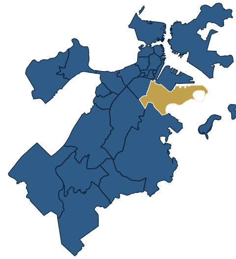
Locator map: South Boston within Boston
Best forWaterfront walks, city beaches, a Revolutionary War site with harbor views, and pubs.
The feelA proud, close-knit residential neighborhood with a long public shoreline. Locals call it Southie.
Getting thereRed Line to Broadway or Andrew; buses 7, 9, 10 and 11 run to City Point, the stop for Castle Island.
From Downtown CrossingAbout 5 minutes on the Red Line to Broadway; about 40 minutes by T and bus to Castle Island.
ParkingTight on residential streets, many of them resident-permit only. The lots along Day Boulevard and at Castle Island fill up on warm weekends.

Quick bites

Broadway’s taverns and chef rooms, Fox & the Knife above all, plus Café Polonia’s pierogi and Sullivan’s hot dogs at Castle Island.

Where to eat

Live on ExploreBoston.com This week’s events, openings and news for South Boston: exploreboston.com/neighborhood/south-boston

Neighborhoods · The map

South Boston

The 3 sights in this chapter, numbered as in the entries that follow; restaurants lettered as in Where to eat

Map: South Boston1/2 miTTTTTTTTTSEAPORTSEAPORTSEAPORTSEAPORTSEAPORTSEAPORTSEAPORTSEAPORTSEAPORTBOSTON HARBORBOSTON HARBORBOSTON HARBORBOSTON HARBORBOSTON HARBORBOSTON HARBORBOSTON HARBORBOSTON HARBORBOSTON HARBOREast First StEast First StEast First StEast First StEast First StEast First StEast First StEast First StEast First StJFK/UMassJFK/UMassJFK/UMassJFK/UMassJFK/UMassJFK/UMassJFK/UMassJFK/UMassJFK/UMassAndrewAndrewAndrewAndrewAndrewAndrewAndrewAndrewAndrewBroadwayBroadwayBroadwayBroadwayBroadwayBroadwayBroadwayBroadwayBroadwaySouth StationSouth StationSouth StationSouth StationSouth StationSouth StationSouth StationSouth StationSouth StationDowntown CrossingDowntown CrossingDowntown CrossingDowntown CrossingDowntown CrossingDowntown CrossingDowntown CrossingDowntown CrossingDowntown CrossingAquariumAquariumAquariumAquariumAquariumAquariumAquariumAquariumAquariumStateStateStateStateStateStateStateStateState123ABCDEFGNT stations: MBTA · Map data © OpenStreetMap contributorsT stations: MBTA · Map data © OpenStreetMap contributorsT stations: MBTA · Map data © OpenStreetMap contributorsT stations: MBTA · Map data © OpenStreetMap contributorsT stations: MBTA · Map data © OpenStreetMap contributorsT stations: MBTA · Map data © OpenStreetMap contributorsT stations: MBTA · Map data © OpenStreetMap contributorsT stations: MBTA · Map data © OpenStreetMap contributorsT stations: MBTA · Map data © OpenStreetMap contributors
Map key

Why go

South Boston runs southeast from Fort Point Channel to Castle Island and Dorchester Bay. For visitors, its best asset is the shoreline: a nearly continuous run of public beaches and paved paths along Day Boulevard that ends at Castle Island, where a 19th-century granite fort looks out over the harbor toward the runways at Logan. Inland, the neighborhood climbs to Dorchester Heights, where George Washington’s cannon forced the British out of Boston in 1776, and spreads across a grid of triple-deckers and rowhouses cut by Broadway, the main street.

Southie has long been known as a working-class Irish American neighborhood, and in recent decades it has also drawn young professionals and families, so old pubs and parish halls now sit next to condos and sit-down restaurants. It is a place people live, not a showpiece. Come for the water, the walk and a meal. If you want museums and historic houses, spend your day downtown instead.

Getting around

The Red Line stops at Broadway and Andrew, both accessible, on the neighborhood’s western side. From there, buses do the rest. Route 9 (City Point to Copley Square) runs the length of Broadway from Broadway station. Route 11 starts on Chauncy Street near Downtown Crossing and runs by South Station and Broadway station to City Point. Route 7 runs from Otis and Summer streets downtown along Summer Street through the Seaport to City Point, and Route 10 connects Andrew with City Point. The City Point Bus Terminal is a short walk from Castle Island.

The shoreline path along Day Boulevard is flat and good for bikes, strollers and wheelchairs. The streets inland climb toward Dorchester Heights, and the monument’s observation deck is reached only by stairs, 72 steps and then a 20-step spiral. Bluebikes has docks at Broadway station, on West and East Broadway and along Day Boulevard near the beaches.

When to go

Summer is beach season, when Castle Island and the loop are at their busiest and Sullivan’s lines are long. Late September and October are quieter and still good for the waterfront walk. In winter the path stays open and the wind comes straight off the harbor.

The neighborhood’s biggest day is the St. Patrick’s Day/Evacuation Day Parade, run by the South Boston Allied War Veterans Council on the Sunday nearest March 17, which is both St. Patrick’s Day and Evacuation Day. Expect very large crowds and street closures, and take the T. On New Year’s Day, the L Street Brownies swim.

A short history

South Boston began as Dorchester Neck, a thin spit of land belonging to the town of Dorchester. On the night of March 4, 1776, the Continental Army dragged cannon onto Dorchester Heights, and on March 17 the British evacuated Boston. In 1804 the Neck became the first piece of Dorchester ceded to Boston, and landfill gradually widened it. Castle Island, fortified since 1634, was finally joined to the mainland by the late 1920s.

From the mid-1800s, Irish immigrants settled here in large numbers and South Boston became a working-class neighborhood, with jobs on the waterfront and in factories such as Gillette. Thomas Park was laid out on the Heights in the 1850s and the monument followed in 1902. In recent decades, rising housing costs and the growth of the Seaport next door have changed who lives here.

Local tips

  • For Castle Island without a car, take Route 11 from Chauncy Street by Downtown Crossing, or Route 7 from Summer Street, straight to City Point. No transfer needed.
  • Walk the Pleasure Bay loop first and finish at Sullivan’s.
  • Bring a layer to Castle Island, even in summer.
  • The grounds at Dorchester Heights are open daily, but the tower opens only for special events, so don’t plan the day around a climb.
  • On parade Sunday, arrive early by T and expect to walk. Driving in is not worth it.

Sights

Places in South Boston

The numbers match the street map .

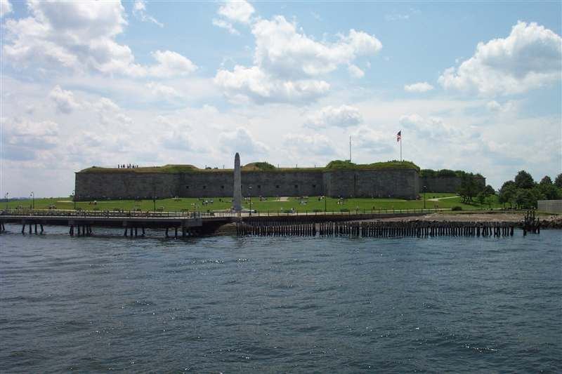
The massive granite walls of Fort Independence above green lawns, seen from the harbor with a pier and stone obelisk in front
1

Castle Island & Fort Independence

Historic SitesMust-see

Address 2010 William J. Day Blvd, South BostonT Broadway (Red), then bus 9 or 11 to City PointHours Sunrise to sunset; fort tours Memorial Day weekend to Indigenous Peoples’ Day weekend: noon–3 p.m. weekends in summer, Sundays after Labor DayAdmission Free, including fort toursPhone 857-702-3884Access Fort accessible on first floor only

Castle Island has been fortified since the 1630s, when Governor John Winthrop ordered the first defenses built here, and the granite, five-bastioned Fort Independence on its crown was begun in 1833 and took nearly 20 years to finish. A teenage Edgar Allan Poe served here under the name Edgar A. Perry; a story he heard about an 1817 duel is said to have fed The Cask of Amontillado.

Landfill tied the island to the mainland by 1928, and the causeway loop around Pleasure Bay is a classic Boston stroll, flat and breezy, with jets sinking toward Logan overhead. Finish at Sullivan’s, the snack stand here since 1951, for a hot dog and a raspberry lime rickey; it stays open into November, long after the beaches empty.

2

M Street and Carson Beaches

WaterfrontIf you have time

Address William J. Day Blvd, South BostonT JFK/UMass (Red), then walk to Day BlvdHours Sunrise to sunsetAdmission FreePhone 857-702-3884Access Seasonal beach mats and beach wheelchairs at Carson Beach

These are the beaches South Boston actually uses: M Street and Carson, side by side on Dorchester Bay, part of a roughly 3-mile run of state-managed shoreline between Pleasure Bay and Carson Beach. The water is calm and shallow, good for wading, and the downtown skyline and the Harbor Islands sit across the bay.

A wide, paved stretch of the Harborwalk runs the whole length, so the strip works as well for a walk or a bike ride as for a swim. Carson Beach, one of the most popular in the city, has the bathhouse; M Street sits closer to Castle Island, and you can walk on to it along the water. Come on a summer weekday morning for elbow room, or out of season for an empty shoreline walk.

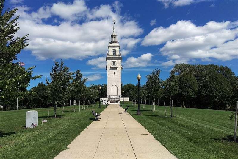
The white marble Dorchester Heights Monument at the end of a straight path through Thomas Park.
3

Dorchester Heights Monument

Historic SitesWorth a visit

Address Thomas Park, South Boston, MA 02127T Andrew (Red), 20-minute walk; or bus 9 or 11 from Broadway (Red) toward City PointHours Grounds open daily; the tower opens only for special eventsAdmission FreePhone 617-242-5601Web nps.gov/bostAccess Wide paved walkways and ramps up a steep hill; the observation deck, when open, is reached only by stairs (72 steps, then 20 more on a spiral stair)

George Washington won his first victory of the Revolution on this hill, and the decisive work took one night. On March 4, 1776, Continental troops under General John Thomas hauled prefabricated timber frames up the frozen slope, muffling the cart wheels with hay, and by daylight cannon from Fort Ticonderoga looked down on the British fleet. On March 17, the British sailed out of Boston.

The 115-foot white marble tower, designed by Peabody and Stearns, went up in 1901–02, and Thomas Park reopened in 2025 after a restoration of the tower and grounds. The observation deck opens only for special events, but the lawns around it look out over South Boston’s rooftops toward downtown. Come late in the afternoon, then walk down to West Broadway for dinner.

Tip There is no public parking nearby; the Park Service suggests parking at Carson Beach or Moakley Park, a 15–20-minute walk away.

Where to eat

Restaurants in South Boston

Broadway is Southie’s dining spine: old taverns and diners near Broadway station share the street with chef-driven dining rooms, and the busy middle stretch of West Broadway is lined with bars and brunch spots. Weekend brunch is a neighborhood ritual, so book or go early.

The letters match the street map .

A

Fox & the Knife

Italian · $$$

28 W Broadway, Boston, MA 02127 · T Broadway (Red Line), 1-minute walk

617-766-8630 · foxandtheknife.com

Chef Karen Akunowicz’s Italian enoteca beside Broadway station, built around handmade pastas, bright antipasti and a deep list of aperitivi and amari. Dinner only, Wednesday–Sunday from 4 p.m.; closed Monday and Tuesday. Reservations open on a rolling 30-day basis on OpenTable, and the bar serves the full menu to walk-ins, first come, first served.

B

Lenox Sophia

Contemporary (prix fixe) · $$$$

87 A St, Boston, MA 02127 · T Broadway (Red Line), 4-minute walk

617-597-2170 · lenoxsophia.com · Reservations recommended; BYOB

A small, Michelin-selected dining room at the corner of A and West Third streets serving a prix-fixe menu, Wednesday–Saturday from 5 p.m. Seatings last 90 minutes, and you may bring your own wine or beer, which makes a special-occasion dinner more relaxed. Book well ahead; same-day cancellations and no-shows are charged.

C

Café Polonia

Polish · $$

611 Dorchester Ave, Boston, MA 02127 · T Andrew (Red Line), 3-minute walk

617-269-0110 · cafepolonia.com

A homey Polish restaurant near Andrew Square, long the center of South Boston’s Polish community, open since 2002 and named a City of Boston Legacy Business in 2026. Order the beet barszcz, potato dumplings and kielbasa, or the duck if you are hungry. Open daily for lunch and dinner, from noon on weekdays and 11 a.m. on weekends; walk in or call ahead for a group.

D

Lincoln Tavern

American · $$

425 W Broadway, Boston, MA 02127 · T Broadway (Red Line), 15-minute walk

617-765-8636 · lincolnsouthboston.com

A big, buzzing West Broadway tavern that pairs home-style American cooking with dishes from a wood-fired grill. Weekday lunch and weekend brunch run until 3 p.m., the brunch drawing a crowd, and a late-night menu runs 10 p.m. to 1 a.m. every night. Tuesdays bring an oyster special. Reserve for weekend brunch or come early.

E

Amrheins

American (diner and tavern) · $

80 W Broadway, Boston, MA 02127 · T Broadway (Red Line), 3-minute walk

Mon–Wed 5 a.m.–2 p.m., Thu–Sat 5 a.m.–10 p.m., Sun 6 a.m.–9 p.m. · 617-268-6189 · amrheinsboston.com

Cooking on West Broadway since 1890, Amrheins opens at dawn for diner-style breakfasts: corned beef hash and eggs, a full Irish breakfast or crème brûlée French toast. Lunch follows every day, and dinner runs Thursday–Sunday. Free on-site parking is a rarity here, and the restaurant takes reservations for dinner.

F

Si Cara

Pizza · $$

400 W Broadway, Boston, MA 02127 · T Broadway (Red Line), 15-minute walk

sicarapizza.com/southboston

The South Boston branch of a Central Square pizzeria and natural-wine bar with a simple-things-done-well approach. Come for pizza and a glass at weekday lunch or weekend brunch, or late Thursday–Saturday, when the kitchen runs until midnight and the lounge opens. Book on OpenTable; groups of six or more should request a table.

G

Sullivan’s Castle Island

Est. 1951

Hot dogs and fried seafood · $

2080 William J. Day Blvd, Boston, MA 02127 · T Routes 7, 9, 10 and 11 buses to City Point (Farragut Road), then a 16-minute walk

Daily 10 a.m.–6 p.m., late February or early March to November · 617-268-5685 · sullivanscastleisland.com · Counter service

Dan Sullivan Sr. opened this stand beside Fort Independence in June 1951, four generations of his family have run it since, and the James Beard Foundation made it an America’s Classic in 2025. The order is a grilled hot dog and a raspberry lime rickey, eaten on the Harborwalk with the planes coming into Logan; the clam strips and chowder are for a second visit. It is seasonal, closed from November to late February or early March; 2026 was its 75th season.

Photo credits

South Boston. Fort Independence on Castle Island seen across the water on a bright day. Robert Linsdell, CC BY 2.0, via Wikimedia Commons (commons.wikimedia.org/wiki/File:Castle_Island_Park,_Boston_(493367)_(24662597450).jpg)

Castle Island & Fort Independence. The massive granite walls of Fort Independence above green lawns, seen from the harbor with a pier and stone obelisk in front. Chris Wood, CC BY-SA 4.0, via Wikimedia Commons (commons.wikimedia.org/wiki/File:Fort_Independence_on_Castle_Island.JPG)

Dorchester Heights Monument. The white marble Dorchester Heights Monument at the end of a straight path through Thomas Park. Jameslwoodward and Louswimmin; crop by ButteBag, CC BY-SA 3.0, via Wikimedia Commons (commons.wikimedia.org/wiki/File:Dorchester_Heights_Monument_04_crop_and_levels.jpg)

All photo credits and license texts